SUSTAINABLE SEA

The water that flows close to your living place runs to the sea.

From March to August 2009 : REGISTRATION and TEACHER'S TIME : The teacher will TAKE 3 photos with a digital camera whose theme will be : water in your town : the closest river or lake or the nearby sea if you live by the seaside. Also write a 50-WORD TEXT in the English language to present these 3 photos and give the name of the sea if needed and send them to the teacher managing the project.

..

Pics01 BOURGOIN-JALLIEU FRANCE : In Bourgoin-Jallieu, the Bion merges with the Bourbre which flows into the Rhône. The Rhône runs down to the MEDITERRANEAN SEA. In 1988 and 1993,The Bourbre and Bion waters overflowed, flooding over the Bourgoin-Jallieu area. The quality of the water is average and efforts are made to clean it up. The first picture represents the Bion and the two other pictures represent the Bourbre.

..

Pics02 MAINZ GERMANY : The Rhine is used for transporting lots of cargo, so this is actually quite ecological. Steinhöfelschule is situated on the Rhine, which has a lovely promenade for strolling and relaxing. The water police see to it that the barges and boats don't get in each other's way. Under the Theodor-Heuss-Brücke there is an office where a chemist and his colleagues examine the chemicals in the Rhine. Their findings are put into a glass showcase, which also contains a fish tank. The Rhin runs to the NORTH SEA.

..

Pics03 ANCONA ITALY : This is the water of the ADRIATIC SEA on the Portonovo Bay, usually the water is quite clean, the white small stones, are similar the one which are in Croatia, which is in front of us, across the Adriatic Sea. This Bay is the favourite place to sunbathing for the people from Ancona. This second photo is taken in Falconara, Ancona,where a oil refinery polluted the the Adriatic Sea, you can see in the distance a pipeline and a ship. Here in the port of Ancona, the water is quite polluted by the dumping of industrial waste and the dumping overboard.

..

PICS04 : KRANJ SLOVENIA : Two years ago a big storm came in our hometown and this river, named Sora which is in surroundings of Kranj, transgressed its banks. It destroyed all things around such as houses, cars and roads. One of the most famous tourist place in Slovenia is Bled which is around 20 km from Kranj. It has a nice Alps surroundings, a beautiful hilly surroundings, a very nice small lake with island which has a church in the middle of lake, a cute castle on the rock upper of lake. We have also a small piece of ADRIATIC SEA. Only around 30 km. It is enough that we can say that we have all : Alps, Adriactic sea and Pannonian plain. This characteristic you can see also on Slovenia Coat of Arms.

..

Pics05 DROBETA TURNU SEVERIN ROMANIA : It is a town situated on the left bank of the Danube, the longest river in the European Union, and the second longest river in Europe, after the Volga. About 8 km away from the town there is the largest hydro power station on this river, The Iron Gates I. The Danube runs down to the BLACK SEA.

..

Pics06 BYDGOSZCZ POLAND : Bydgoszcz is a city in northern Poland, on the Brda and Vistula rivers and Bydgoszcz Canal. The Brda is a hydrographic axis of the city. It is very picturesque tributary of the Vistula. The Vistula is one of the most important and the longest rivers in Poland at 1,047 km in length. It empties into the Vistula Lagoon or directly into the Gdansk Bay of the BALTIC SEA. The Brda is part of the Odra-Vistula waterway, connecting these two rivers via the Warta and Notec Rivers and the Bydgoszcz Canal since end of the XVIIIth century. Today the fact of neighboring a river does not play any important part in transportation development. Between 1st May and 31st October citizens and tourists can enjoy Bydgoszcz water trams on the Brda river. The unit, called SLONECZNIK (sunflower), is the first in Poland (and possibly in Europe) passenger inland waterway vessel with solar panels and batteries as the basic propulsion power source.

..

Pics07 WHYALLA SOUTH AUSTRALIA : The first photo features Whyalla Marina, a popular spot to catch playful dolphins in action. The second photo is of Fitzgerald Bay and then we have Point Lowly. Our vast coastlines are all connected. All it takes is a 30-minute drive to Fitzgerald Bay, an aquaculture industry and then to Point Lowly which boasts the grand Lighthouse. Whyalla is also known as the ‘Cuttlefish Capital’ as it is home to the giant cuttlefish. These giant molluscs (yes, they are not fish) come to breed in our pristine waters between May and September every year. The sea in Whyalla is the SOUTHERN OCEAN.

..

Pics08 STRZELCE OPOLSKIE POLAND : Strzelce Opolskie is a town in south-western Poland. The closest river is the Oder river (in Polish : Odra), the second longest river in Poland after the Vistula. Oder begins in the Czech Republic, flows through western Poland and empties into the BALTIC SEA through the Szczecin Lagoon. In July 1997 after several days of heavy rain waters of Oder and some other rivers overflowed causing the worst flooding in post-war Poland, Germany and the Czech Republic. The first two photos represent the Oder river in Krapkowice, a town situated 20 km from Strzelce Opolskie. The third photo shows one of the Turawa artificial lakes, a very picturesque area 30 km from Strzelce.

..

Pics09 WROCŁAW POLAND : Wrocław is situated on the Odra River which begins in the Czech Republic and flows through western Poland into the BALTIC SEA. The Odra and the Lusatian Neisse form the Oder-Neisse line, which was designed after World War II as the new border between Germany and Poland. Wrocław is defined by the river with its tributaries and canals, the 12 islands and over 100 bridges that cross the Odra. However, in 1997 the river overflowed affecting the city heavily. Around one-third of the city’s area stood under water. Nowadays the banks of the river have been regulated and the quality of water is being improved within “The Programme for the Odra -2006”. The first picture presents “an old bed” of the river whereas the second and third show in their backgrounds the oldest part of Wrocław, called Ostrów Tumski, including the two towers of magnificent Gothic Cathedral of St. John the Baptist in the middle one.

 ..

Pics10 HURBANOVO SLOVAKIA : Picture 01: Hurbanovo is situated on Sub-Danube Plain, in west-south of Slovakia which is bounded by the Danube and other Slovak rivers: the Dudváh, the Malý Dunaj, the Váh, the Nitra and the Žitava. These rivers, which were regulated in the previous centuries, belong to the Danube Basin and the Danube flows into the Black sea. The lowland is a rich well-drained soil. There are a lot of thermal springs and spas. In addition, there is a significant water power and the Danube´s locks in Gabčíkovo. Actually, the region is considered to be important source of drinking water for Europe. Hurbanovo lies on the right bank of the river Žitava. In the past the river was rapid and it threatened people with floods and swampy banks. On the other hand, it was much cleaner and the peasants used to collect crayfish. Nowdays it forms the region of magic river nooks and dead arms, the area of standing water, bogs and wetlands which are home to the protected aquatic birds and plants. There are a lot of nature reserves. One of the most charming is Apalský ostrov which can be found at the confluence of the Žitava and the Nitra. Picture 02: The largest port and shipyard in my country on the banks of Danube´s side arm in Komárno which is approximately 15 km far from Hurbanova and lies on the banks of the Danube and the Váh. The city districts are linked with bridges. There are docks and an opening bridge in the photo. Picture 03: The River Váh is the longest in Slovakia. In the past there were a lot of watermills on the river banks and it was navigated only by rafters. Now there are some small water powers on the river. Also the river creates a lot of side arms which offer fabulous sports facilities and holiday camps. In the photo there is a traditional floating watermill on the bank of the Váh at Kolárovo which is approximately 25 km far from Hurbanovo. The Danube runs down to the BLACK SEA.

..


Pics11 ATHENS GREECE : Kifissos is the longest river in Athens. It comes from the natural hub of Penteli and Parnitha mountains. It dichotomises the capital city and our suburb as well and finally ends in Saronic Gulf close to Moschato – Faliro area. The river Kifissos was source of life for the vast, fertile plain. According to ancient Greek mythology, Kifissos was the river God who presided over the largest river of the Athenian plain. Its form was shown on the fronts of the Parthenon. It caused most of the wealth of Attica and of Athens but a big part of its beauty was lost due to the big and the brutal "abuse" by the inhabitants. At the beginning of 2007 some groups began a major campaign to save the river. “Kifissos is still breathing; will we save it? – It can be done...” The Kifissos runs down to the MEDITERRANEAN SEA.

..

Pics12 SINGAPORE : The first two photos show Punggol River which is going to be developed into a new recreational area for waterfront sports. This river flows into the JOHOR STRAITS which is the sea that separates Singapore from Malaysia. Singapore is a small city state and most of the rivers in Singapore are channelised to prevent flooding as Singapore experiences high amount of rainfall throughout the year. Therefore, it is quite difficult to see any rivers in its natural state, except for a few rivers in the nature reserve.

..

Pics13 SOLIKAMSK RUSSIAN FEDERATION : Solikamsk is located on the Usolka that flows into the Kama. Both the rivers have picturesque scenery giving the people a chance to enjoy and relax. The Karma goes to the Volga river and then to the CASPIAN SEA. We express a great concern about their purity as we live in an industrial area. We are eager to preserve the beauty of the rivers for the next generations.

..

Pics14 UMEÅ SWEDEN : Umeå is situated near the Umeå River, who is regulated by hydropower plants. Outside Umeå we can find the GULF OF BOTHNIA, a link for transportation of gods from the Västerbotten County. Small lakes are situated in the surrounding of Umeå, and the inhabitants visit them during the weekends for picnic, fishing and bathing. The first picture : the Gulf of Bothnia. The second picture : the Umeå river enter the Gulf of Bothnia. The third picture : one of the small lake.

..

Pics15 DZIERZGON POLAND : Dzierzgon is a small town in northern Poland. The town of Dzierzgon lies on the river Dzierzgon. 
It starts west of Morag in the Warmia-Masuria Province and empties into Lake Druzno south of Elblag. It is 45 km long.
In January 2005 after several days of heavy snow and rain waters of the Dzierzgon river overflowed causing the flooding in the nearby fields.
The ??? River runs down to the ........????? SEA

..

Pics16 DONOSTIA-SAN-SEBASTIAN SPAIN : IES Zubiri-Manteo is located in the east end of San Sebastian. This is the Cantabric Sea we can see from our school windows. From the west end of the city we took this other photo to show La Concha’s Bay. The city is divided in east and west by Urumea River, which flows into the CANTABRIC SEA.

..

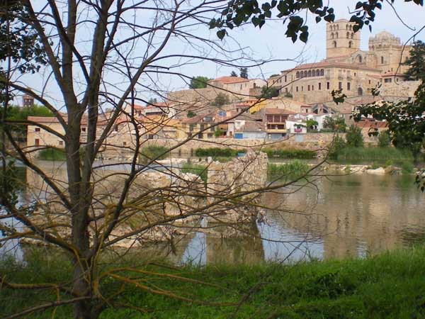
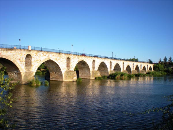
Pics17 ZAMORA SPAIN : These photographs show different views of the River Duero in Zamora. This river, the third longest in the Iberian Peninsula crosses the country and, on its way through Zamora, serves as both frontier and union with Portugal, where it continues its course until it flows into the Atlantic Ocean. The first photograph shows in the foreground the River Duero and the ruins of an old Roman bridge, and at the top Zamora´s Romanic Cathedral whose dome is a true symbol of the whole city. The second photograph shows the Romanesque bridge with its sixteen pointed arcs. The old “Vía de la Plata” (Silver´s Way), crossed it. The third one is a photograph of the so-called “Aceñas de Olivares”, three old water wheels, nowadays used to represent the traditional trades related to metallurgy, textile and flour industries. The river runs down to the ATLANTIC OCEAN.

..

Pics18 HAGEN GERMANY : Our school is situated next to the "Volme" which merges with the "Ruhr". The "Ruhr" flows into the "Rhine" which runs down to the NORTH SEA. In the (pre-) industrial age mills, smiths and foundries arose along the "Volme" from which the iron industry developed. In Hagen the "Volme" was most mostly canalized and is now being renaturalized.

..

Pics19 CADIZ SPAIN : Sancti Petri spout flows between the towns of San Fernando, Chiclana de la Frontera and Puerto Real (Cádiz), has a winding tour of 18 km in length, putting on communication the free waters of the ATLANTIC OCEAN with the Cádiz bay waters. Its depth varies considerably from the tour. The channel is deeper at the ends, and very succinct in the central zone. Boquerón Tip is a coastal area in the south of the municipality of San Fernando. Belongs to the environment of Park Natural Bay of Cádiz and can be accessed by walking from the Camposoto Beach, Virgin Beach of San Fernando. Often archaeological rest are found , like the defensive walls of the 19th century, from the War of Independence that still remains. Sancti Petri islet is located in the mouth of Sancti Petri, spout offshore Beach Camposoto and Boquerón tip. In the 1st century BC Strabo recalls the founding of Cadiz, Tirios stood up a shrine dedicated to Melkart, primitive figuration Hercules, in antiquity was joined to the Cadiz island by a road today disappeared into the sea , althought there are traces of it.

..


Pics20 CARCAVELOS PORTUGAL : Our school is situated only 400 metres from Carcavelos beach, a richly touristic location, into which flows the 'ribeira' de Caparide/Manique, one of many 'small rivers' in the Cascaís area, close to Lisbon and the huge Tejo river. The ribeiras de Cascaís provide some rich, green valleys that, following neglect, have recently been cleaned up by volunteers. Cascaís is provided with water by the nearby reservoirs such as Lagoa Azul. The Sintra hills provide a damp micro climate which help to bring much-needed rain. The river runs down to the ATLANTIC OCEAN.

..

Pics21 ARUCAS LAS PALMAS SPAIN : Water is scarce in Arucas, our home town in the north of Gran Canaria, one of the Canary Islands, just off the north coast of Africa, in the ATLANTIC OCEAN. The first photograph presents a “cantonera”, a typical local device to distribute water among farmers. The second picture is “Las Salinas”, the traditional sea salt mines. The third one shows one of the most popular recreational local areas, “El Puertillo”, the ideal place to relax.

..

Pics22 BRYANSK RUSSIAN FEDERATION : Bryansk is situated on the Desna River which originates in the city of Smolensk and after its confluence with the Seim River flows through a low and muddy plain across the Russian-Ukrainian border until it reaches the Dnieper River near Kiev, the capital of Ukraine. The Desna freezes over from early December to early April. The banks of the Desna River are a popular place of rest for thousands of the Bryansk residents. Local authorities are concerned about the purity of the water and every year some measures are taken to keep the river clean so that the people can enjoy the beautiful and picturesque surroundings. Pictures 1, 2 and 3 show the river during different times of the day. The Desna is the longest tributary of the Dnieper River which runs down to the BLACK SEA.

..

Pics23 ZAWIERCIE POLAND : Zawiercie is situated on the river Warta which has its sources in a small town of Kromolow near Zawiercie. The first picture shows that place. The Warta River flows to the north-west and joins the Odra River near the border with Germany. The Odra River is the second biggest river of Poland and it flows into the BALTIC SEA. There are many natural ponds and lakes near Zawiercie. The second picture shows one of the ponds in the forest in Borowe Pole district. The third picture shows a lake in Poreba near Zawiercie.

..

Pics24 BUZAU ROMANIA : The Buzău River is a river in eastern Romania, tributary of the Siret River. Its total length is 302 km. Its source is in the south-eastern Carpathians Mountains, east of Brasov. The Black Sea is an inland sea bounded by Europe, Anatolia and the Caucasus and is ultimately connected to the Atlantic Ocean via the MEDITERRANEAN SEA and Aegean Seas and various straits. The Danube Delta is the second largest delta in Europe, after the Volga Delta, and is the best preserved on the continent. The greater part of the Danube Delta lies in Romania (Tulcea county), while its northern part, on the left bank of the Chilia arm, is situated in Ukraine (Odessa Oblast).

 ..

Pics25 FULDA GERMANY : Geography: The Fulda is 220,7 km long and one of the biggest rivers in Hesse. It flows from the Hessian part of the Rhoen (highest peak: Wasserkuppe). The Fulda unites with the Werra at Muenden (Lower Saxony) and forms the Weser River which flows into the NORTHSEA. There are 109 km navigable by boat. Recreation: There is a nice and recreative atmosphere on the banks of the Fulda River. This area is called “Aueweiher”. It’s famous for its pastime activities on the jogging, biking, and walking tracks. Some prefer to sit and fish trout, though. A speciality is the “Rhön-Forelle” offered in many restaurants. You can even join the Canoe Club. Its members have already won gold medals at championships. Fauna and Flora: The Fulda is considered to be a green river with algae, reed, moss, grass and a rich diversity of flowers. Fishes like eel, brown trout, perch, pike, and zander; and birds like: swans, ducks, beautiful insects like dragon-flies and butter-flies have their habitat there. You can even meet water snakes if you take a swim in the Fulda.

..

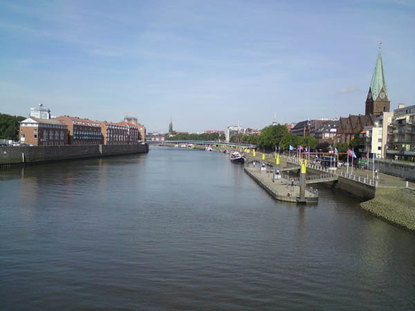
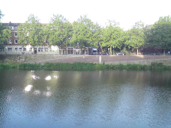
Pics26 BREMEN GERMANY : Photo 1 – River Weser : This picture is taken where the river Weser flows through the city centre of our hometown Bremen. It is a Hanseatic city with a long historical development. The town occupies an area of 325,42 km² and inhabits 548.477 people (April 2008). The population density is 1.685 inhabitants/km². The river Weser is the most important landmark in Bremen. With its 440 km it is one of the largest rivers in Germany. The mouth of this river is located in Bremerhaven, a town belonging to Bremen. Both towns are approximately 70 km apart from each other. In the photo you can sea the oldest part of Bremen on the right hand side. It was first mentioned in official documents in the year 782. Since 1806 its name is Free Hanseatic City. On the left hand side you see the newer part of the town. A very modern development we find close to this area where old store houses are being reconstructed to provide space for modern offices and lofts. Photo 2 – Beluga College : This view shows our college building right behind the huge trees lining the river bank at the so-called Little Weser. It is a smaller branch of the river, because right in the city centre the Weser is divided into two parts by an island named Teerhof. On this island the headquarters of Beluga Shipping Company is situated in a wonderful new building which was only opened in June this year. Beluga College started its work August 1st this year. At the moment we have 25 students of 15 and 16 years of age and 10 members of staff, not all of them full time. Our college offers two so-called profiles: maritime-commercial and maritime-technical. It provides bilingual education in German and English. The qualification will be the German Abitur. Photo 3 – North Sea : This is the mouth of the river Weser where it flows into the NORTH SEA. On the left you see the green nature of the state of Lower Saxony and on the right are the cranes of the important container port in Bremerhaven. It is so amazing how nature and industry are so close to each other in this region. This is always an issue for environmental activists and politicians. Right at the mouth of the river the famous mudflats of the North Sea are located. They belong to the National Park Wattenmeer.

..

Pics27 AZOV RUSSIAN FEDERATION : Our native town Azov is situated on the banks of the small and picturesque river Azovka (Photo 1 ) and the Don river (Photo 2). The Don River is the fourth-longest river in Europe. It flows for a distance of about 1 950 km, crossing our hometown and entering the Gulf of Taganrog in the Sea of Azov. Known to the ancients as the Tanaïs, the Don has been a trading route since Scythian times. (Photo 3 )The Azov Sea is a shallow (a maximum depth of 9 m) inland sea on the northern Black Sea. From the hydrological point of view, the Azov Sea is a bay (lagoon) of the Black Sea, and therefore it could be considered as a part of the BLACK SEA.

..

Pics28 HODONIN CZECH REPUBLIC : The Morava is a river in Central Europe. It is the most important and biggest river of Moravia, which derives its name from it. The river Morava flows through the whole southern part and 
it is used for sports and recreational purposes. In summer there are small and middle-sized boats on the river that make use of the separate port in Rohatec with future connection with the Bata-Channel which is for now navigable from the turnplace for ships to Sudoměřice and to the tipper where there is a boat hire. The Morava meets the Danube in Bratislava – Devín and runs down to the BLACK SEA. The third photo shows the Velička stream which is a smaller left-side tributary of the River Morava. The town Strážnice is located on the Velička River.

 ..

Pics29 SANTIAGO DE COMPOSTELA SPAIN : Sarela river, shown in the first picture, has its origin in Santiago de Compostela. Its water flows through the Ria de Arousa leading to the ATLANTIC OCEAN. Picture 2, shows Compostela´s beach, where people picking cockles and clams can be seen. This industry is very sensitive to sea pollution, due to the overflow of fuel from some cargo boats, like the Prestige some years ago in the Galician coast. Sailers have their own Patron Saint, La Virgen del Carmen, it takes place the 16th of July, and make a big fiesta to celebrate it.

..

Pics30 GORNA ORIAHOVICA BULGARIA : Gorna Oryahovitsa is a city in northern Bulgaria. The closest river is Yantra. The city is situated on the right bank of the river. The Yantra has its source from the Central Stara Planina. Special features of the river are the many gorges it forms by crossing the Fore Balkan area. Yanra`s length is 285km and runs into the right bank of the Danube close to Svishtov. The Danube flows into the BLACK SEA.

..

Pics31 PITESTI ROMANIA : The Argeş river (photo 1) is in Southern Romania. It springs from the Făgăraş Mountains, in the Southern Carpathians and flows into the Danube at Olteniţa. The main city on the Argeş is Piteşti, our town (over 160.000 inhabitants). Upstream, it is retained by the Vidraru Dam (ranked 5th in Europe, and 9th in the world), which has created Vidraru Lake(photo2). The Danube is flowing into the BLACK SEA. (photo 3: The Black Sea at Vama Veche, during the "Folk You" Festival).


Pics08 A


Pics08 A


Free counter and web stats